|  | |
 | Devils Canyon | |
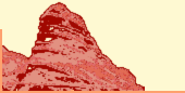
|  | Location: | Utah • Emery County • San Rafael Swell | 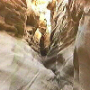 | | Nearby: | | | | Gas, Lodging: | Green River, Hanksville, Salina | | | Hikes: | Dutchman Arch, Eye of Sinbad, Black Dragon Wash, Farnsworth Canyon, Ding Canyon | | | Attractions: | Goblin Valley State Park, Arches National Park, Capitol Reef National Park, Canyonlands National Park | | Info: | Moderate day hike | | Description: | | | Devils Canyon is south of I-70, Exit 114. The day before we made this hike we checked out the dirt road going down to Devils Canyon from the view-point above. We found that the road looked okay. Actually the road ... read more |
|
|